|
Lockman Butte
Elevation 3790'
Lockman Butte is located in the foothills of the Danskin Mountains, right on the edge of the Snake River Plain. This is desert terrain in south central Idaho, just north of Mountain Home. Lockman Butte itself isn’t particularly noteworthy, but it offers pretty decent views, and is just a short drive from Boise.
I was looking for something close to home that would still be accessible given recent new snow. Lockman seemed about right, so I made the 45 minute drive to where I would start the hike, at the end of the pavement on Canyon Creek Road. Based on the maps, I was starting on private land, but with my limited research, this was the only way across Canyon Creek. (I later read Tom Lopez’s description, which is a better options.)
After walking north along Canyon Creek, and then through a cow pasture, I then turned west and made my way up through the sagebrush toward the butte. A blanket of a couple inches of new snow added a little adventure, and I arrived on the highpoint after just under 2 miles of hiking.
Skies were cloudy, so views were limited. After a snapping a few photos, it was time to head back. I retraced my path back to my vehicle, and made it back without issue. Round trip was just under 4 miles and 500’ of elevation gain in just under 2 hours of hiking. Nothing exciting, but still good to get out, stretch my legs, and breathe some fresh air.

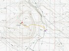
Map of the route, just under 4 miles and 500' gain round trip. |

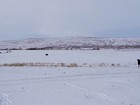
Lockman Butte from the cow field. |

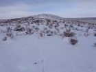
Nearing the summit of Lockman Butte. |

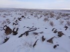
Old triangulation tripod on the summit. |

Summit selfie on Lockman Butte. |
|
|
|
