|
Mount Greylock 6-Pack of Peaks
|
Related Links:
- FireLookout.com Info
- IdahoLookouts Info
- Estes Mountain Mining History
- Trailhead Location
- My GPS Tracks
- West Park Creek Peak: TL, PB, LOJ, Map
- Mount Greylock: TL, PB, LOJ, Map
- Greylock Point: TL, LOJ, Map
- East Park Creek Peak: LOJ, Map
- Greylock Crown Peak: LOJ, Map
- Estes Mountain: TL, LOJ, Map
|
Mount Greylock is located near the southern edge of the Salmon River Mountains, above the Yankee Fork, not far north of Stanley Idaho. Greylock is an impressive mountain, home to a fire lookout that dates back to 1934. No doubt there was once a trail the summit, but it’s no longer evident. However, thanks to a trailhead over 9000’ elevation, reaching Greylock is a manageable hike. Plus, there are a handful of other peaks nearby that create opportunities to explore.
JJ and I met in Stanley then made the drive to the trailhead just east of Estes Mountain. The road coming up from Jordan Creek was rugged but not too bad with high clearance. It was a beautiful cool morning, and we made quick work of the initial climb up (Peak 9366’) before descending the ridge southeast, and then south, before skirting around the east side of Point 9380’. From here, we had a view of Greylock’s north ridge. We could see some steep sections ahead, but pressed on.
The climbing got steeper as we climbed the north ridge of Mount Greylock. There were a few scrambly sections, and a few others with loose talus, but we were able to make it without much technical difficultly. Plenty of huffing and puffing though.
The fire lookout tour on the summit of Mount Greylock had seen better days, but it was still interesting to look inside and scout around the summit looking at artifacts. The views from the top were amazing. We could see the vast Frank Church Wilderness, Sawtooths, White Clouds, Boulders, Pioneers, and even Mount Borah in the distance.
We chose a spot next to the lookout building to get out of the wind and have lunch. After lunch and a bunch of photos, it was time to head down. After all, we had more peaks to cover. The descent down Greylock’s north ridge was pretty easy, but sidehilling back to the saddle west of “Greylock Point” (Peak 9403’) was painful.
Once back at the saddle, we made the quick climb up Greylock Point, and then eyed a couple more peaks to the north. The first was objective was “East Park Creek Peak” (Peak 9477’), which was a straightforward ridgewalk. From here, we could see the impressive “Greylock Crown Peak” (Peak 9621)’ looming to the east. It had a hulking summit block with no obvious route up. JJ decided to take a break while I opted to give the rugged peak a shot.
So off I went, down the ridge and up the somewhat sandy slops to the base of the cliffs below the summit. I traversed across the slopes toward the north side of the peak. It was sandy at first, then ball-bearing style loose pebbles later. I eventually found a bit of stable rock that led me up a steep gully and some low fourth class scrambling that led to ridge and then the summit.
“Greylock Crown Peak” (Peak 9621)’ was no gimme, and I enjoyed a snack on the wild summit. Instead of trying to downclimb the steep gully, I decided to continue clockwise around the peak and found a weakness in the southeast ridge that led me down to gentler slopes below the cliffs. Now all I had to do was get my hustle on to catch up with JJ, who would be waiting at the saddle south of our earlier peak.
Once I caught up with JJ, we descended west from the saddle toward the headwaters of Park Creek. There were some elk trails that made things easier. Next we climbed back up to the ridge we had been on earlier, and made our way back to the car. But the day wasn’t done. JJ had unfinished business to deal with on Estes Mountain, and I happy to accommodate and try for a sixth peak of the day too.
We walked the road toward the north side of Estes, passing by old miner cabins along the way, and even an old mill. Estes Mountain is heavily scarred by mining activity. We followed the road all the way around to the north ridge of Estes, and started climbing from there. The road took us part way up, and then we hiked up the final rocky slopes to reach the summit. The distant views were great, including Greylock to the south. But most noticeable was the massive mining activity at the Sunbeam Mine below us on the other side of Jordan Creek. It was a bit breezy on the summit, and it was getting late, so we made a quick descent down the east ridge of Estes Mountain, and back to the trailhead.
What a fantastic day in the mountains. It was great to explore new terrain and tag six summits in the process. Round trip was almost 11 miles and 4500’ gain to cover all 6 peaks in just over 8 hours. Only slightly less distance and gain for the 5 peaks that JJ did.
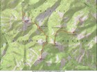
Map of the route, 11 miles and 4500' gain round trip. |
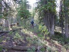
Early part of the hike, little evidence of trail. |
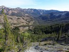
Nice view down the Park Creek drainage. |
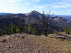
Early view of Greylock from “West Park Creek Peak” . |
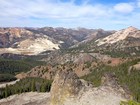
Mount Jordan and The General in the distance, Estes Mountain to the right, Grouse Creek Mine activity below. |
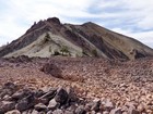
Looking up the ridge toward Mount Greylock. |
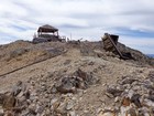
Lookout and outhouse on the summit of Mount Greylock. |
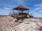
Old fire lookout on the summit of Mount Greylock |
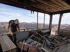
Checking out the fire lookout. |
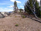
Nearing the summit of Greylock Point. |
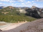
View of Peak 9477' and Peak 9621' from Greylock Point. |

Victory shot on the summit of "East Park Creek Peak" (Peak 9477'). |
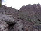
Steep gully used to reach the summit of "Greylock Crown Peak" (Peak 9621'). |
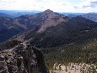
Mount Greylock and Greylock Point from Greylock Crown Peak. |
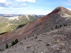
Final stretch to the summit of Estes Mountain. |
|
|
|


