|
Humbug Mountain
Elevation 1761'
Humbug Mountain is located in southern Oregon, right next to the Pacific Ocean. It seems to be the tallest coastal mountain in Oregon. There is a trail leading all the way to the summit, which climbs steadily up through old growth forest and lots of vegetation, which is very pretty but allows for only occasional views of the ocean.
We were in the midst of a family vacation, and I was able to tackle Humbug Mountain while my wife and kids enjoyed the beach nearby. The only stipulation was that I needed to be fast. So up the trail I went, doing my best to hustle. It was nice and shady, but I was warmed up in hurry thanks to the steady uphill grade.
The trail was nice, and I enjoyed the old growth forest, ferns, and moss covered trees. After a mile or so, I reached the fork that allowed for a summit loop. I chose the east trail, which would be longer but not as steep. The higher I got, the more light there was, which made for several cool scenes with the sun shining through the canopy above.
The summit itself wasn’t overly impressive, but there was a bench to sit on and I could almost see the ocean. On the way down I took the west trail, which had thicker vegetation and more of a jungle feel, which was cool. I passed several hikers headed up, and made it back to the trailhead in just under two hours. Round trip was 5.5 miles and 1800’ elevation gain.
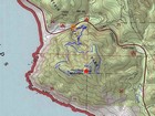
Map of the route, 5.5 miles and 1800' gain round trip. |
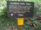
Trailhead sign for Humbug Mountain. |

Typical trail conditions down low. |

Mossy creek crossing. |
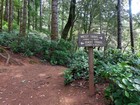
The trail forks to create a nice summit loop. |

Sunlight on mossy trees. |

More light as the trail nears the summit. |
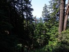
Fleeting view of the Pacific Ocean. |
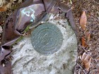
Humbug Mountain summit benchmark. |
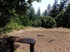
Bench on the summit, almost a view of the ocean. |
|
|
|
